Reserva natural garganta de los infiernos
valley of the jerte cherry trees
The Garganta de los Infiernos Nature Reserve belongs to the «Network of Protected Natural Spaces of Extremadura». It was declared Reserve by Decree 132/1994 of November 14, 1994, published in the DOE of November 22, 1994.
The main rocks found are granites and gneiss. The highest altitudes are reached in the Cuerda de los Infiernillos (2,281 m.) and the Cerro del Estecillo (2,290 m.) that surround the Garganta de la Serrá, an ancient glacial valley that was modeled by the passage of Quaternary ice.
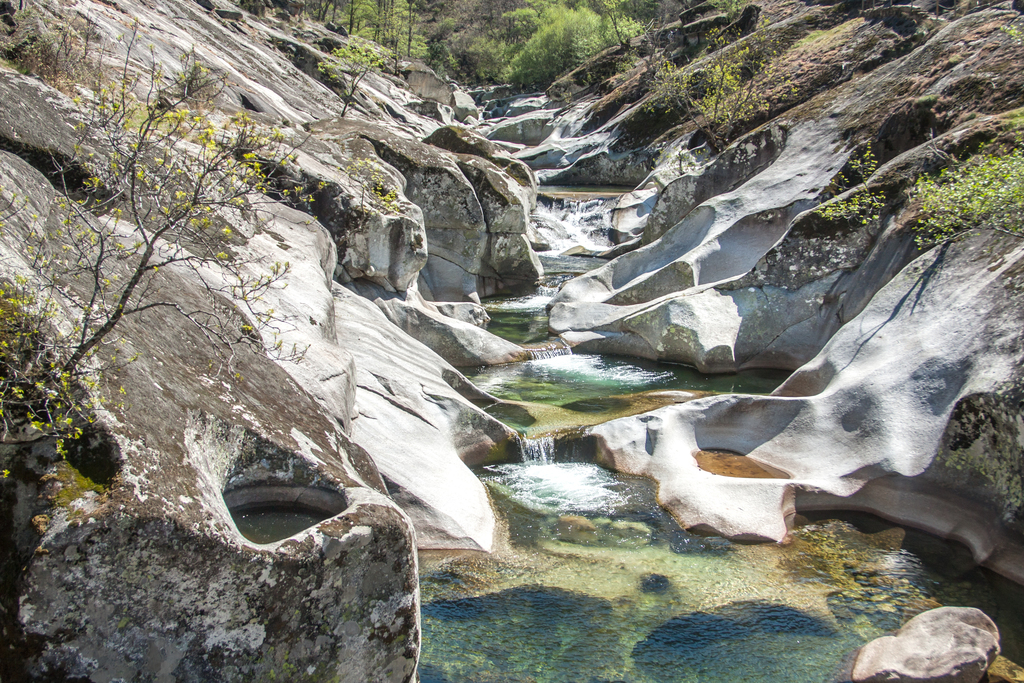
The Natural Reserve has a wide hydrographic network with abundant waterfalls and cascades, one of the main peculiarities of this natural space. Special mention should be made of the giant marmitas, which are large pools carved into the rock by fluvial erosion, highlighting those that exist in the area known as Los Pilones.
The climate offers notable contrasts depending on the altitude. In general, winters are moderately cold and summers are not very hot. Rainfall in the area ranges between 1,500 and 2,000 mm. Annual, being frequent in winter the snow in the mountain peaks.
kayak monfragüe
The reserve is located between the northwestern slope of the Sierra de Tormantos, the southwestern slope of the Sierra de Gredos and the Jerte River. Located at the head of the Valle del Jerte region, it is the gateway to the Autonomous Community of Extremadura from the province of Avila.
The reserve has abundant waterfalls, streams, waterfalls, natural pools and large pools dug by the circular erosion of river water. The high humidity levels in turn contribute to a vegetation of great ecological value with deciduous forest ecosystems, riparian forest, mountain meadows and alpine pastures. The fauna is autochthonous and very abundant, harboring several endangered species.
The climate offers notable contrasts depending on the altitude. In general, temperatures are not extreme, with moderately cold winters and mild summers. Rainfall in the area ranges between 1500 and 2000 mm per year, with frequent snowfall in winter on the mountain peaks.
hiking in the jerte valley
The main Interpretation Center is located in Jerte, at the entrance of the Park, where you can get a lot of information thanks to its panels and models, along with explanatory videos that can be seen by appointment.
One of the most characteristic aspects of this reserve is the large number of water formations, such as gorges, waterfalls and the Marmitas de Gigante. Due to the large amounts of snow that are stored in the high peaks, with the thaw come rapid streams of water to the river Jerte. Precisely because of these currents we can observe in the area of Los Pilones a phenomenon known as «marmitas».
Reserva natural garganta de los infiernos 2022
Located in the heart of the Jerte Valley, the Garganta de los Infiernos Natural Reserve is known for its waterfalls and waterfalls. From the Sierra de Tormantos to the southwestern slope of the Sierra de Gredos, the course of the Jerte River molds landscapes of granite and gneiss.
The highest point is the Cuerda de los Infiernos, at more than 2,000 meters above sea level, and the Cerro del Estecillo, a former glacier, is considered the origin of this attractive geographical feature.
But it is undoubtedly the place of the «Pilones» or the «giant marmitas» the most numerous set of pools excavated naturally by fluvial erosion. Due to the unevenness in this area, with oscillation changes between 300 and 2000 meters of altitude, different ecosystems coexist in the area.
The Natural Reserve Garganta de los Infiernos allows the practice of numerous hiking trails, enjoying some of the most beautiful places in the region of Jerte such as: Los Pilones, the Route of Carlos V, the Cordel del Valle and the route through the Alta Extremadura.
Soy Emilio Velazquez webmaster y principal redactor de webinstant.es . Me encantan los perros y el café caliente por las mañanas.
